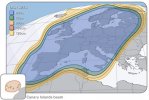
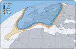
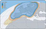
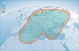
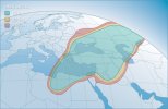
But when she was relocated to 28.2E two were listed.... Have a look at the north beam lobe covering the Canary Islands - according to that map most of the power is covering the seas to the west of the islands! That has to be an mapping error on the part of the SES drawing staff.
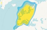
Heuvos has pointed out that the coverage areas on the maps in posts 1 & 4 are similar, but the map projection has changed - and having had a second look yes I suppose they are very similar
This site uses cookies to help personalise content, tailor your experience and to keep you logged in if you register.
By continuing to use this site, you are consenting to our use of cookies.
")