
SEOShamsher
Member
- My Satellite Setup
- Past setup:
• 8-ft dish covering 68.5°E, 75.0°E (Ku), 78.5°E, 83.5°E, 90.0°E, 93.5°E (Ku), 100°E, 105.5°E, 115.0°E
• 6-ft dish at 49.0°E
• Receivers: COSHIP CDVB2000B, Dish TV Zinga
Current status:
Sold all equipment — want to start again from scratch.
- My Location
- Ludhiana, Punjab, India
I was checking the beam footprint map for Amos 3 (now replaced by Dror 1) at 4°W and noticed something that confused me.
As you can see in my screenshots, there is a clear horizon limit line running vertically near my location in Ludhiana, Punjab, India. Everything to the right of that red line northern India, is technically outside the geometric horizon for this satellite. Elevation there is below 0°
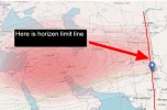
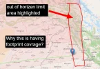
But here is the strange part — the satellite footprint coverage map still shows signal coverage (red shading) extending well into that below-horizon zone. Almost all of areas in red are -0.5° BELOW THE HORIZON!
My questions:
As you can see in my screenshots, there is a clear horizon limit line running vertically near my location in Ludhiana, Punjab, India. Everything to the right of that red line northern India, is technically outside the geometric horizon for this satellite. Elevation there is below 0°
But here is the strange part — the satellite footprint coverage map still shows signal coverage (red shading) extending well into that below-horizon zone. Almost all of areas in red are -0.5° BELOW THE HORIZON!
My questions:
- Is this a mapping error in the footprint , or is there a real technical reason why coverage is shown in areas that are geometrically below the satellite's horizon?


