Are satfinders worth the money? Need help with dish alignment.

nucleus

Member
Joined
Mar 17, 2011
Messages
11
Reaction score
0
Points
0
Age
45
My Satellite Setup
None
My Location
CY
Two days ago I installed a small satellite dish on my roof. Since then, I have tried various ways of properly aligning it with Hot Bird 6/8/9 at 13.0°E.

Closest I got to doing it is this.
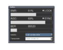
osdshot.png
So I thought about buying one of these

_http://www.sat-link.co.uk/store/Digital-Satellite-Finder-Meter-DVB-S-WS-6908-WS_6908_SATLINK.html

But I am wondering. How will this help me align the dish? Will it actually show me exactly where to tilt it, horizontally and vertically?

I guess my question here is, do you guys think that this thing will actually help me get the job done?
Also, if you do not recommend this, can you provide any tips and tricks to help me allign the dish?

Tnanks

[warning]Live External Link disabled - Please see Forum Rules[/warning]
 

Lazarus

Retired Moderator
Joined
May 29, 2009
Messages
27,084
Reaction score
8,672
Points
113
My Satellite Setup
80cm Motorised.
Several small Dishes.
Much else.
My Location
North York Moors
You shouldn't need any meters to align to a strong Satellite like Hotbird.

Check out the Forum link to Dish Pointer to give you a practical line of sight.

Also, start aligning with the dish face vertical by eye and just tweak the direction (not the elevation) at this stage until you get a signal.

Then use your Receiver to scan and, from the Channels you actually get, correlate with the listings on Flysat or Lyngsat or KingofSat etc. to determine which Satellite you've found: If it actually is Hotbird, then fine, but if it proves to be Astra 1, Astra2 or whatever, then at least you have a starting point. If you need to move the dish further east, you may need to lower the elevation a tiny bit, or if you have to move further west, then it may need to be raised a tad.

Don't be misled by selecting Hotbird in your Receiver and assuming that if you get a signal it must be from Hotbird - all a "Satellite" is as far as the box is concerned is an often out of date data table - and frequencies and other parameters are re-used right across the arc.


Edit: I have just realised you are in Cyprus, so the starting elevation is not with dish face vertical! It will be somewhat higher.

However, you can do the work using Dishpointer - this will give you the required elevation which you can apply either by use of a graduated dish bracket (if it has a scale on it) - although these are only approximate and don't cater for a mount which is not vertical. Or you can guesstimate an approximate dish face angle by subtracting the LNB arm offset (usually around 25 deg) from the true elevation.

Also, the minor adjustments to elevation required as you pan the arc will only broadly follow my original advice as 13E is far nearer to your due South than it is in UK!

If unsure, once you've found a Satellite and proved which one it is, look at the dishpointer figures for both that Satellite and for Hotbird and you will see immediately how much to move it in bearing and how much (and which way) in elevation.
 
Top