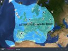
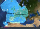
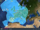
I've attached the iOS versions of the Europe footprints for 2E, 2F and 2G. It's interesting that they have shown the "45cm" limit from launch, including 2F and 2G which are still not on the SES website.
I'm also a little concerned about 2G's Europe footprint as it would suggest only England and Wales are covered by the 45cm area which would mean zone 2 dishes will still be needed in Ireland and Scotland for optimum service after 2A and 28A are shut down and goes against the idea that SES are trying to even the power across the UK and Ireland so everyone can use a zone 1 dish (as shown by 2F and 2E). So either 2G Europe will only be used as backup or the footprints are wrong or will be tweaked to favour the UK (in which case, why publish this one?).
Knowing my luck, as 2G Europe is the only beam that covers southern Finland with a semi decent signal, this is the one that won't be used....
Edit: Having just looked at the SES website, it seems they have updated the data for 2G to include the following text:
"Total transponders Ku-band: 10*
Ka-band: Europe:4
(250 & 500 & 600 MHz), *incremental capacity. Not an indication of technical capability."
It's a bit unclear what this means, as the satellite covers West Africa, UK and Europe, but if they are only planning to use 10 transponders then it sounds like it will be mainly backup and filling in a few gaps as I feared.