Since nobody has time to provide me that information, & 4wd seems to believe i should do it myself because the provided method is believed to be given,
i'll follow his procedure & show you why nothing makes sense & why it's a waste of time doing it myself:
Following the 4wd "method" in a non objective response:
1) As mentionned,
Satbeams - World Of Satellites at your fingertips can.
Are you "trying" to tell me to go to
Satbeams - World Of Satellites at your fingertips ?
-Done.
2) "Click on any of the sat symbols on top"
-A sat symbol, trying to translate: a satellite icon ? any ?
-Done.
3) "choose a beam"
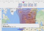
-There are beams on squared maps above the main big map, & beams on the main map.
-I have no choice to make sorry (nothing can allow me to make choices at this point, since selecting a given beam
to me on a world map out of the blue for having selected any "satellite" icon, is not relevant at all.
-I also don't know how you had Madeira selected on your attached picture.
-I can imagine you added the blue lines..... even though i don't see the purpose.
-I also see in that beam that England's included when i'm not supposed to receive Uk beams without a dish of 4m minimum.
4)"Spend time (Done), read, learn"
"then plan" ?... .
5) That was at least useful, thanks:
"Then look up any satellite that seems possible in your area (using f.ex.
FlySat Sat List) to see which sat\channels may be of interest."
So for the Gibertini, if anyone can tell me which satellites are at my disposition without magic explanations that lead me nowhere
or not detailed enough, that could help me.
As mentionned,
Satbeams - World Of Satellites at your fingertips can.
Click on any of the sat symbols on top, choose a beam, click within the footprint graphics.
Then look up any satellite that seems possible in your area (using f.ex.
FlySat Sat List) to see which sat\channels may be of interest.
Spend time, read, learn, then plan.