Eutelsat 13C now Eutelsat 12 West G @ 12.5° W

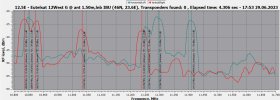
Today I examined all the screenshots saved by crazyscan, from the evening of June 18th until today at 13:00 (Italian time GMT+2).

21 Txp are active, data, test carrier, etc... The times reported refer to the first appearance (the variations, such as the addition of modulation and various things, are not reported).
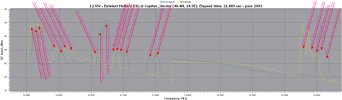
12.5W-RFScan_2993.png
 
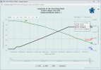
At last Real time satellite tracking for: EUTE HOT BIRD 13C (HB 9) has been updated :) they must have been on a long break :eek:

EUTE HOT BIRD 13C (HB 9)

Eutelsat 12 West G @ 12.5° W​


NORAD ID:33459
LOCAL TIME:10:09:42
UTC:09:09:42
LATITUDE:-0.08
LONGITUDE:-12.53
ALTITUDE [km]:35777.79
ALTITUDE [mi]:22231.29
SPEED [km/s]:3.07
SPEED [mi/s]:1.91
AZIMUTH:195.7 SSW
ELEVATION:+29.8
RIGHT ASCENSION:02h 38m 07s
DECLINATION:-08° 34' 59''
Local Sidereal Time:03h 34m 03s
The satellite is in day light​
SATELLITE PERIOD:1442m
​
pixel.gif
 
Last edited:
In any case, both satellites are centered at 12.5°W, with inclination up to 2.4° (12 West E) and 0.15° (12 West G).
 
Would 0.15 inclination need accounted for by say a 1.5-1.8m dish or is it within error at the moment?
 
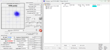
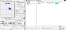
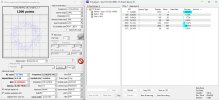
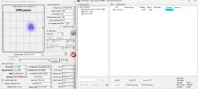
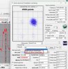
Two more (S2X extension) muxes have been activated:11033 V,32725,13/45, S2X and 11411 H,30000,13/45, S2X-Data.
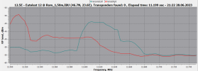
Finding the signal parameters in the upper band is still impossible.
 

Attachments

  • 11033 V,32725,13.45,s2-data_2023-06-28_21-12-11.png
    11033 V,32725,13.45,s2-data_2023-06-28_21-12-11.png
    111 KB · Views: 24
  • 11411 H,30000,13.45,s2-data_2023-06-28_21-07-37.png
    11411 H,30000,13.45,s2-data_2023-06-28_21-07-37.png
    106.1 KB · Views: 18
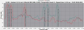
  • 12.5W__10800-11700 HV__2023-06-28_21-05-57.png
    12.5W__10800-11700 HV__2023-06-28_21-05-57.png
    96.9 KB · Views: 14
  • 12500-127500 HV___2023-06-28_21-22-17.png
    12500-127500 HV___2023-06-28_21-22-17.png
    49.1 KB · Views: 15
11240 V,31428,1/2,S2-packetized,new
added: The 11240 V also uses S2X mode.
 

Attachments

  • .10800-12700 HV__2023-06-29_17-53-56.png
    .10800-12700 HV__2023-06-29_17-53-56.png
    98.7 KB · Views: 10
  • 11240 V,31428,12,s2-packetized_2023-06-29_18-06-51.png
    11240 V,31428,12,s2-packetized_2023-06-29_18-06-51.png
    116.1 KB · Views: 9
  • 11240 V,31428,25.36,s2,0.05-data_2023-06-29_18-27-32.png
    11240 V,31428,25.36,s2,0.05-data_2023-06-29_18-27-32.png
    107.9 KB · Views: 21
Last edited:
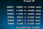
Active transponders at this moment with TM-5402 M4
 

Attachments

  • Active tps Eutelsat 12 West G @ 12.5° W.png
    Active tps Eutelsat 12 West G @ 12.5° W.png
    1.7 MB · Views: 26

Attachments

  • 12240 V,31428-dummy & dvbs2_2023-06-30_07-59-32.png
    12240 V,31428-dummy & dvbs2_2023-06-30_07-59-32.png
    231.7 KB · Views: 29
Would 0.15 inclination need accounted for by say a 1.5-1.8m dish or is it within error at the moment?


There should only be marginal impact from a 0.15 degree inclination on a 1.5m dish for a decent strength signal
It depends on your link margin, if it is a borderline lock situation with perhaps a few tenths of a degree margin then you could see some impact.

When 30.9E was inclined a few years ago and in daily use by SIS I was tracking it with a 1.5m prime focus dish.
There was no "bite" from the incline until it started to creep up to perhaps 0.3 degrees inclined and even then I maintained a lock without the need to activate dual axis tracking.

Another way of thinking about it is to compare the 0.15 degree incline to Azimuth adjustment with a v-box.
A v-box generally gives 11 to 12 clicks to a degree on a 36V H-H motor such as a Jaeger 1224, approximately equivalent to 0.08 - 0.09 degree per click.
If you are dead centre peaked on the satellite and you marginally move off by 1 to 2 clicks on a v-box, the signal variation is in the area of magnitude of a 0.15 degree incline.
 
Are there any pictures yet from Eutelsat 12 West G @ 12.5°W, or is it all wavy line stuff for the spectra men?
 
The only pictures we get on 12.5W are the data/parameters, probably in the testing phase(?).
I'm not sure, but I think the muxes(data only) from 33.1E(11200-11500 HV) are moved here or work simultaneously at two positions(?).
 
Last edited:
Latest TLE shows the old Eutelsat 12 West E (incl. 2.4°) has left 12.5°W, drifting 0.5°W/day.
Next TLE, the drift rate will probably be more, it can also be the end-of-life orbit raising.
 
The TLE is incorrect, Eutelsat West E is now approximately 18°W.
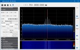
The telemetry 11701,80 H is currently active.

E12WE_11701.80_H.png
 
1689251986741.png
I think it's safe to assume now, Eutelsat 12 West E is sent to graveyard orbit.
Originally named Eutelsat W2M, the satellite was intended for 16°E but had a major power failure, and could never have many transponders on.
Launched Dec 2008, not too bad it almost lasted 15 years.
 
TM-5402 M4:
Italian channels on 13E,notably La 7
Does it still work or do I need another update (latest was March 2023)
 
Is 12.5W the next satellite slot to be abandoned above Europe? Eute 12 West G has left the slot and is drifting westwards
 
Hmmm 12.5W is no longer listed on the Eutelsat site


No idea when it was removed - its been a while since Ive had a look at the Eutelsat site.
 
Hmmm 12.5W is no longer listed on the Eutelsat site


No idea when it was removed - its been a while since Ive had a look at the Eutelsat site.
12 West G showed (as inclined) on some fleet maps inside investor presentations, it was never listed on the "main" GEO fleet page.
 
Back
Top