- Joined
- Jul 26, 2003
- Messages
- 50,798
- Reaction score
- 11,252
- Points
- 113
- Location
- Scottish Borders
- My Satellite Setup
-
TM 5402HD
Sky+ UK.
- My Location
- Scottish Borders
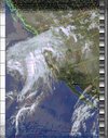
Most remarkable is perhaps the red colours - what's that thing happening in Barcelona??NOAA 19 16:14 GMT Northbound.83 W Mel 3 W 137.100
View attachment 116910
Most remarkable is perhaps the red colours - what's that thing happening in Barcelona??

looking at google maps a bit more, it's clear that it's not actually Barca.Could be the Catalonia hot spot.
Most remarkable is perhaps the red colours - what's that thing happening in Barcelona??

