
You are using an out of date browser. It may not display this or other websites correctly.
You should upgrade or use an alternative browser.
You should upgrade or use an alternative browser.
Astra 2G: Pre-Testing Phase
- Thread starter timo_w2s
- Start date
- Status
- Not open for further replies.


- My Satellite Setup
- Triple Dragon, Dreambox 8000, Echostar AD3000ip, TBS6522,6925,6983 PCie cards.
Gibertini 1.25m motorised dish driven by the AD3000, with either Inverto BU Quad or Norsat / XMW Ka LNBs . SMW 1.05m + 3 other dishes. Speccy: Promax HD Ranger+
- My Location
- The Flatlands of East Anglia
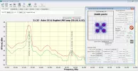
Another 21.2E carrier at 20150. Can't be the usual Milsat at 20250, that's not on the Arc at present.
2G?
2G?
- My Satellite Setup
- Triple Dragon, Dreambox 8000, Echostar AD3000ip, TBS6522,6925,6983 PCie cards.
Gibertini 1.25m motorised dish driven by the AD3000, with either Inverto BU Quad or Norsat / XMW Ka LNBs . SMW 1.05m + 3 other dishes. Speccy: Promax HD Ranger+
- My Location
- The Flatlands of East Anglia
Not so sure now, signal has increased significantly over the last hour. Maybe another inclined bird?
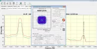
Another carrier coming up now on 20360.
Another carrier coming up now on 20360.

hvdh
Specialist Contributor
- My Satellite Setup
- Dr.HD F16, TBS 5927, T-55, Laminas 120 cm
- My Location
- Oss, NL (5.5°E 51.8°N)
Of course we're both thinking of SBIRS-Geo 2, that crossed the belt 25 minutes ago (19:24 UTC).
But SBIRS is at 19.4°E according a quite recent TLE of 21 March.
I suppose you can distinguish well for a difference of almost 2° in location?
And it would be rather strange if SBIRS uses both within and outside the military band (20.2...21.2 GHz).
But SBIRS is at 19.4°E according a quite recent TLE of 21 March.
I suppose you can distinguish well for a difference of almost 2° in location?
And it would be rather strange if SBIRS uses both within and outside the military band (20.2...21.2 GHz).
- My Satellite Setup
- Triple Dragon, Dreambox 8000, Echostar AD3000ip, TBS6522,6925,6983 PCie cards.
Gibertini 1.25m motorised dish driven by the AD3000, with either Inverto BU Quad or Norsat / XMW Ka LNBs . SMW 1.05m + 3 other dishes. Speccy: Promax HD Ranger+
- My Location
- The Flatlands of East Anglia
I'm certain I'm dead on 21.2E. Carriers disappear when I move to 21.6 or 23.5E.
What I'm not certain of is if my Hughes LNB LO hasn't shifted frequency, giving wrong scan readout. - It's modified for tunable LO.
I'll check against a known satellite frequency (W3A 12.5W or 5W).
What I'm not certain of is if my Hughes LNB LO hasn't shifted frequency, giving wrong scan readout. - It's modified for tunable LO.
I'll check against a known satellite frequency (W3A 12.5W or 5W).
hvdh
Specialist Contributor
- My Satellite Setup
- Dr.HD F16, TBS 5927, T-55, Laminas 120 cm
- My Location
- Oss, NL (5.5°E 51.8°N)
OK, I hope you'll check also if indeed signals peaked about an hour ago.
Meanwhile, I'll update the database that I use to filter out geo sats from the McCants TLE file.
Maybe you're onto an unseen satellite!
Meanwhile, I'll update the database that I use to filter out geo sats from the McCants TLE file.
Maybe you're onto an unseen satellite!
- My Satellite Setup
- Triple Dragon, Dreambox 8000, Echostar AD3000ip, TBS6522,6925,6983 PCie cards.
Gibertini 1.25m motorised dish driven by the AD3000, with either Inverto BU Quad or Norsat / XMW Ka LNBs . SMW 1.05m + 3 other dishes. Speccy: Promax HD Ranger+
- My Location
- The Flatlands of East Anglia
OK, LNB LO was way off true, now correct (I was doing some testing last time I used the Hughes, and forgot to adjust it back).
Nothing scanning in at present, I'll have to try tomorrow morning when SBIRS-Geo 2 appears again, or anything else around the band.
Nothing scanning in at present, I'll have to try tomorrow morning when SBIRS-Geo 2 appears again, or anything else around the band.
- My Satellite Setup
- Triple Dragon, Dreambox 8000, Echostar AD3000ip, TBS6522,6925,6983 PCie cards.
Gibertini 1.25m motorised dish driven by the AD3000, with either Inverto BU Quad or Norsat / XMW Ka LNBs . SMW 1.05m + 3 other dishes. Speccy: Promax HD Ranger+
- My Location
- The Flatlands of East Anglia
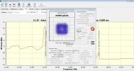
OK, this morning I have two carriers, 20250 and 20460, I think they're synchronised in strength, so possibly the same satellite, SBIRS-Geo 2.
I'll watch 20460 to see if that's the case.
I'll watch 20460 to see if that's the case.
hvdh
Specialist Contributor
- My Satellite Setup
- Dr.HD F16, TBS 5927, T-55, Laminas 120 cm
- My Location
- Oss, NL (5.5°E 51.8°N)
The ITU database has a clue: on 20.6°E, a USA satellite (nick)named USOBO-5A is registered.
Transponders (bandwidth):
20252.5 (4 MHz)
20452.5 (4 & 5 MHz)
20462.5 (5 MHz)
20752.5 (200 MHz)
The trouble that bothers me now, is the SBIRS-Geo 2 TLE, that apparently has the correct belt crossing time, but wrong longitude. I can trace back at least for half a year, the TLE always had 19.2...19.4°E. But always found this rather strange, another satellite so close to the 19.2°E Astra constellation.
Transponders (bandwidth):
20252.5 (4 MHz)
20452.5 (4 & 5 MHz)
20462.5 (5 MHz)
20752.5 (200 MHz)
The trouble that bothers me now, is the SBIRS-Geo 2 TLE, that apparently has the correct belt crossing time, but wrong longitude. I can trace back at least for half a year, the TLE always had 19.2...19.4°E. But always found this rather strange, another satellite so close to the 19.2°E Astra constellation.
- My Satellite Setup
- Triple Dragon, Dreambox 8000, Echostar AD3000ip, TBS6522,6925,6983 PCie cards.
Gibertini 1.25m motorised dish driven by the AD3000, with either Inverto BU Quad or Norsat / XMW Ka LNBs . SMW 1.05m + 3 other dishes. Speccy: Promax HD Ranger+
- My Location
- The Flatlands of East Anglia
The two carriers I found (only the two showing here) must be on the same satellite, unless there are two perfectly co-located (unlikely I would have thought). Their signal amplitude rises and falls completely in sync.
hvdh
Specialist Contributor
- My Satellite Setup
- Dr.HD F16, TBS 5927, T-55, Laminas 120 cm
- My Location
- Oss, NL (5.5°E 51.8°N)
Yes thanks, it's clear now. I guess the wide 200 MHz transponder is where hi-res IR images/video are downlinked.
But apparently, not always on, or spot-beamed.
Is 20.6°E (nominal) within an acceptable margin for you?
But apparently, not always on, or spot-beamed.
Is 20.6°E (nominal) within an acceptable margin for you?
- My Satellite Setup
- Triple Dragon, Dreambox 8000, Echostar AD3000ip, TBS6522,6925,6983 PCie cards.
Gibertini 1.25m motorised dish driven by the AD3000, with either Inverto BU Quad or Norsat / XMW Ka LNBs . SMW 1.05m + 3 other dishes. Speccy: Promax HD Ranger+
- My Location
- The Flatlands of East Anglia
Not too sure about that. Checking the 21.2E 2G beacon @18800, where I have the two carriers, shifting the dish westwards towards a nominal 20.6E drops the beacon level down.
hvdh
Specialist Contributor
- My Satellite Setup
- Dr.HD F16, TBS 5927, T-55, Laminas 120 cm
- My Location
- Oss, NL (5.5°E 51.8°N)
The SBIRS-Geo 2 discussion don't really belong in this thread, but need to finalize it!The ITU database has a clue: on 20.6°E, a USA satellite (nick)named USOBO-5A is registered.
Transponders (bandwidth):
20252.5 (4 MHz)
20452.5 (4 & 5 MHz)
20462.5 (5 MHz)
20752.5 (200 MHz)
The trouble that bothers me now, is the SBIRS-Geo 2 TLE, that apparently has the correct belt crossing time, but wrong longitude. I can trace back at least for half a year, the TLE always had 19.2...19.4°E. But always found this rather strange, another satellite so close to the 19.2°E Astra constellation.
After PM/email discussion with Llew and others, it is now confirmed Llew received above 2 frequencies from SBIRS-Geo 2, that is located at 20.6°E (nominal).
The wrong longitude values (19.3°E) for SBIRS Geo 2 that I mentioned above are caused by a DLL called DJTSabLib.dll that GorbTrack, WXtrack, and probably also some other tracking softwares use.
The bug is apparent only on some inclined satellites.
I can't figure out the further conditions leading to wrong longitude output!
Unfortunately, the author of the DLL has told me it is very unlikely he will fix it.

It has hardly been maintained for many years. It is open source though.
- My Satellite Setup
- Triple Dragon, Dreambox 8000, Echostar AD3000ip, TBS6522,6925,6983 PCie cards.
Gibertini 1.25m motorised dish driven by the AD3000, with either Inverto BU Quad or Norsat / XMW Ka LNBs . SMW 1.05m + 3 other dishes. Speccy: Promax HD Ranger+
- My Location
- The Flatlands of East Anglia
Thanks for the info Hans.
That's SBIRS Geo 2 put out of its misery on this thread, just 2G to consider here now - when we get any upcoming reports.
That's SBIRS Geo 2 put out of its misery on this thread, just 2G to consider here now - when we get any upcoming reports.

Marcus_21
Specialist Contributor
- My Satellite Setup
- Motorized dish Gibertini 150 cm + Space Digital SDLNB4 + actuator QARL 24"+ GBOX V3000... Motorized dish Gibertini 125 cm + Inverto Pro Quad PLL + actuator 18" + V-Box II.
- My Location
- 40.7N - 14.5E
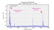
Astra 2G is moving to east, at this time is about 23,5°E.....

Lazarus
Retired Moderator
- My Satellite Setup
- 80cm Motorised.
Several small Dishes.
Much else.
- My Location
- North York Moors
Astra 2G is moving to east, at this time is about 23,5°E.....
Can you supply a source for this, please?
Marcus_21
Specialist Contributor
- My Satellite Setup
- Motorized dish Gibertini 150 cm + Space Digital SDLNB4 + actuator QARL 24"+ GBOX V3000... Motorized dish Gibertini 125 cm + Inverto Pro Quad PLL + actuator 18" + V-Box II.
- My Location
- 40.7N - 14.5E
- Status
- Not open for further replies.